Fitxer:Cathead with inner and outer whisker guys. - Schooner C.A. THAYER, Hyde Street Pier, San Francisco, San Francisco County, CA HAER CAL,38-SANFRA,199-13.tif

Mida d'aquesta previsualització JPG del fitxer TIF: 800 × 580 píxels. Altres resolucions: 320 × 232 píxels | 640 × 464 píxels | 1.024 × 742 píxels | 1.280 × 928 píxels | 2.560 × 1.855 píxels | 5.000 × 3.624 píxels.
Fitxer original (5.000 × 3.624 píxels, mida del fitxer: 17,28 Mo, tipus MIME: image/tiff)
Resum
| Cathead with inner and outer whisker guys. - Schooner C.A. THAYER, Hyde Street Pier, San Francisco, San Francisco County, CA | ||||
|---|---|---|---|---|
| Fotògraf |
Lowe, Jet Related names:
|
|||
| Títol |
Cathead with inner and outer whisker guys. - Schooner C.A. THAYER, Hyde Street Pier, San Francisco, San Francisco County, CA |
|||
| Lloc representat | California; San Francisco County; San Francisco | |||
| Data | 1988 | |||
| Dimensions | 5 x 7 in. | |||
| Lloc actual |
Library of Congress Prints and Photographs Division Washington, D.C. 20540 USA http://hdl.loc.gov/loc.pnp/pp.print |
|||
| Número d'inventari |
HAER CAL,38-SANFRA,199-13 |
|||
| Crèdits d'adquisició |
|
|||
| Notes |
|
|||
| Referències |
|
|||
| Font | https://www.loc.gov/pictures/item/ca1506.photos.041950p | |||
| Permís (Com reutilitzar aquest fitxer) |
|
|||

| Posició de l'objecte | | Aquesta i altres imatges properes a: OpenStreetMap |
|---|
Historial del fitxer
Cliqueu una data/hora per veure el fitxer tal com era aleshores.
| Data/hora | Miniatura | Dimensions | Usuari/a | Comentari | |
|---|---|---|---|---|---|
| actual | 16:20, 3 jul 2014 | 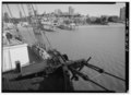 | 5.000 × 3.624 (17,28 Mo) | Fæ | GWToolset: Creating mediafile for Fæ. HABS batch upload 2 July 2014 (301:400) |
Ús del fitxer
La pàgina següent utilitza aquest fitxer: